
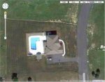
Your Pool - from SPACE
- Thread starter kenmar
- Start date
You are using an out of date browser. It may not display this or other websites correctly.
You should upgrade or use an alternative browser.
You should upgrade or use an alternative browser.
Nice looking place! That's a fairly low level aircraft photo, not a satellite image. Many states that have a lot of agriculture pay for the aircraft photography.
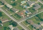
Ha, cool idea! Here's mine. Google Earth (the stand-alone program) has a feature where you can see the same site on various dates...pretty cool. This one is from Nov. 20, 2009.

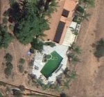
And, from May 30, 2005:

And, from May 30, 2005:
Hmmm, interesting, would these low level aircraft images make it on to Google Earth?That's a fairly low level aircraft photo, not a satellite image
bk406
0
JohnT said:That's a fairly low level aircraft photo, not a satellite image.
Google earth is satellite images, not aircraft. If they were aircraft, you couldn't zoom out like you can. Yes, satellite imagery is that good.
A pic from google earth from my previous house:

Really amazing what satellites can do.
Really amazing what satellites can do.
bk406 said:JohnT said:That's a fairly low level aircraft photo, not a satellite image.
Google earth is satellite images, not aircraft. If they were aircraft, you couldn't zoom out like you can. Yes, satellite imagery is that good.
No, Google earth uses aircraft images when they are available. That kind of resolution comes from aircraft at only a few thousand feet.
From the Wikipedia article:
"Most land areas are covered in satellite imagery with a resolution of about 15 m per pixel. This base imagery is 30m multispectral Landsat which is pansharpened with the 15m [panchromatic] Landsat imagery. However, Google is actively replacing this base imagery with 2.5m SPOTImage imagery and several higher resolution datasets mentioned below. Some population centers are also covered by aircraft imagery (orthophotography) with several pixels per meter. "
Note that 2.5 meter resolution means you can see a car. If you can identify the model, it is an aircraft photo.
bk406
0
JohnT said:bk406 said:JohnT said:That's a fairly low level aircraft photo, not a satellite image.
Google earth is satellite images, not aircraft. If they were aircraft, you couldn't zoom out like you can. Yes, satellite imagery is that good.
No, Google earth uses aircraft images when they are available. That kind of resolution comes from aircraft at only a few thousand feet.
Especially the oblique shots like what vln posted (available on Bing and elsewhere). That kind of imagery may be possible from satellites (depends on how much Tom Clancy you read
bk406
0
Ok, so most are satellite, some are aircraft. Yes, the oblique pict is for sure aircraft.
Learn something new everyday.
Learn something new everyday.
Looking at my image more closely, is see PAMAP/USGS written on the bottom.
Googling PAMAP/USGS, I find http://www.dcnr.state.pa.us/topogeo/pamap/index.aspx
This site states that PA is indeed using low level aircraft to map the entire state.
Ya learn something new everyday!
Googling PAMAP/USGS, I find http://www.dcnr.state.pa.us/topogeo/pamap/index.aspx
This site states that PA is indeed using low level aircraft to map the entire state.
Ya learn something new everyday!
The last time the Google Earthbots were over our house was in 2004. I guess I see where we stand in the big scheme of things....no pool to show. Their loss!
Try Bing Maps... I us it for my online clients in other states. It has a bird's eye feature that allows you to see the house form N,S,E, and W as long as they have the photos. I was even able to tell a client where their septic system was from the air. The one picture was when they were building the house and caution tape could be seen where they had put the tank in.
Bing maps look really old, the view of my house is at least 4 years old, Google is up to date.
But the Bing maps pan feature is nice
But the Bing maps pan feature is nice
Some of their photos are really good and others aren't so good. the good ones ar usually aroung growing communities it seems.
Google Earth seems to have a function where they update areas with very old imagery if lots of people start looking at it all of a sudden.
We did a job in SE Alaska last summer in the middle of nowhere. In the planning stages, we did a lot of Google Earth-ing around the area, but the imagery wasn't good. After a few dozen people were looking at this one spot all the time, they updated the imagery, which meant we had to re-do a bunch of work! Much better results though. It could have just been a coincedence, but Google is pretty smart about such things so I suspect they were paying attention.
We did a job in SE Alaska last summer in the middle of nowhere. In the planning stages, we did a lot of Google Earth-ing around the area, but the imagery wasn't good. After a few dozen people were looking at this one spot all the time, they updated the imagery, which meant we had to re-do a bunch of work! Much better results though. It could have just been a coincedence, but Google is pretty smart about such things so I suspect they were paying attention.
csoukup6
0

I work for a large Geogrpahic Information Systems (GIS) company, we were using "Google Earth" before there even was a Google.
You'd be amazed at the amount of data that most municipalities have these days and the sophisticated ways in visualizing it.
In our situation we have virtually every municipal and utility feature (water/sewer mains, poles, hydrants, your lot and house footprint, assessment info, meters, cables, pumps, road edges, etc etc) geographically located and sitting overtop satellite imagery.
It pretty amazing and the commercial grade software is far more powerful than Google Earth, Googles major feat is delivering something so solid to the masses that is easy to use.
Thread Status
Hello , This thread has been inactive for over 60 days. New postings here are unlikely to be seen or responded to by other members. For better visibility, consider Starting A New Thread.